Washington Has More Natural Variety Than Most People Realize Washington State has more designated wilderness area than any other state in the contiguous US — over 4 million acres. Most people picture Seattle, maybe Mount Rainier on a clear day. What they don’t picture is an ancient lava tube you can walk through in near-freezing […]
Washington Has More Natural Variety Than Most People Realize
Washington State has more designated wilderness area than any other state in the contiguous US — over 4 million acres. Most people picture Seattle, maybe Mount Rainier on a clear day. What they don’t picture is an ancient lava tube you can walk through in near-freezing darkness, a lake so chemically pure it has almost no aquatic life, or a stretch of eastern Washington that looks more like Iceland than the Pacific Northwest. The state packs rainforest, active volcanic terrain, high desert, glacier-fed lakes, and one of the most dramatic coastlines in North America into a single road trip.
Whether you are planning a week-long Washington State road trip or just want to know which places in Washington State are actually worth the detour, this list covers 30 real spots — with specific details on fees, permits, best timing, and what makes each one different from the one before it.
If you still need to sort out where to stay near the parks, Super tends to surface the best deals for accommodation in smaller gateway towns — worth a look before you book.
1. Olympic National Park — Three Ecosystems, One Park
Olympic is one of the few places in the world where you can walk from an old-growth temperate rainforest to an alpine meadow to a wild Pacific coastline without leaving the same park. Entry is approximately $30 per vehicle (covered by the America the Beautiful Annual Pass). One important logistics note most first-timers miss: there is no single road that connects the whole park. Plan your driving time carefully — moving between the Hoh Rain Forest, Hurricane Ridge, and the coastal strips can take 2–3 hours each way.
2. Hurricane Ridge — Alpine Views Above the Clouds
Hurricane Ridge sits at about 5,242 feet inside Olympic National Park and gives you one of the most accessible high-elevation views in the state. On clear days you can see the Strait of Juan de Fuca and Vancouver Island. The road to the ridge is typically open year-round on weekends in winter for snowshoeing, but check current conditions before driving up — it closes on weekdays in the off-season. No separate fee beyond the park entry.
3. Hoh Rain Forest — The Quietest Place You’ll Visit
The road into the Hoh Rain Forest narrows as you get deeper in. Moss covers everything — the trees, the fallen logs, the branches overhead. The light that gets through is green. It is quiet in a way that feels deliberate. The Hoh receives up to 140 inches of rain per year, making it one of the few temperate rainforests in North America. The Hall of Mosses trail is 0.8 miles and remains one of the most photographed forest walks in the Pacific Northwest. Included in Olympic NP entry.
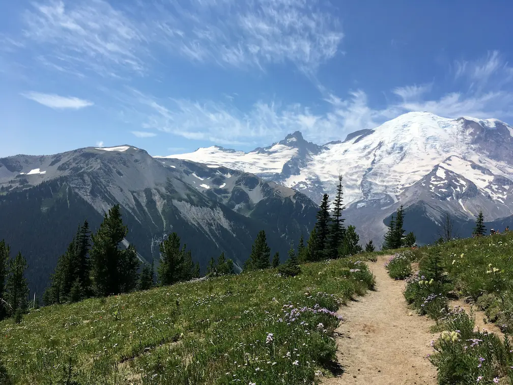
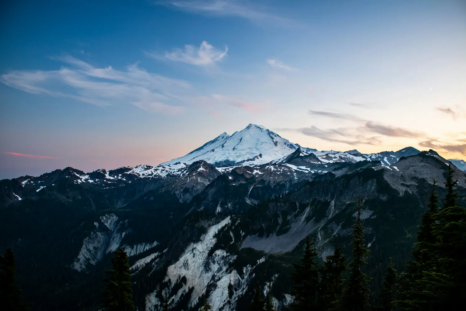
4. Mount Rainier National Park — The Mountain That Defines the Skyline
At 14,411 feet, Rainier is visible from Seattle on clear days, but it takes about two hours to actually reach the park from the city. Entry is approximately $30 per vehicle. The Paradise area is the most popular section for good reason — in July and August, the wildflower meadows at this elevation are at their peak, and the short trails from the visitor center give you sweeping views of glaciers. Arriving early on summer weekends is still a smart move for parking.
5. Paradise Area, Mount Rainier — Wildflowers at Elevation
Paradise sits at around 5,400 feet and consistently ranks as one of the snowiest places on Earth where weather data has been recorded for an extended period. In summer that same snowfield becomes the base for short, well-marked hikes through wildflower meadows with the summit looming above. Even if you are not a hiker, the views from the parking area alone justify the drive. Stay for sunset if you can — the light on the glaciers changes fast.
6. Sunrise, Mount Rainier — Highest Paved Road in the Park
Sunrise sits at 6,400 feet, making it the highest point you can reach by paved road inside Mount Rainier National Park. It is also notably less crowded than Paradise, even in peak season. The views of the mountain here are arguably more dramatic because you are looking across rather than up. The visitor center typically opens in early July and closes in late September depending on snow. Covered by Mount Rainier NP entry (approximately $30/vehicle).
7. North Cascades National Park — The Least Visited of the Three
North Cascades has no entry fee for the park itself, though some campgrounds charge fees. The park sees a fraction of the visitors that Olympic and Rainier receive, partly because Highway 20 — the main access road — closes in winter, typically from November through April. The landscape here is more rugged and remote than the other two parks. Late June through September is the most reliable window for visiting.
8. Ross Lake National Recreation Area — Adjacent to North Cascades
Ross Lake sits just inside the North Cascades complex and shares the same dramatic mountain backdrop. The lake stretches north into Canada. Unlike the main park, Ross Lake NRA has more visitor infrastructure — boat-in camping, a floating resort, and access points along Highway 20. It is a good base if you want more than a single-day visit to the North Cascades area.
9. Johnston Ridge Observatory — Face to Face with the Crater
Johnston Ridge gives you a direct, unobstructed view of the Mount St. Helens crater from about five miles out. The 1980 eruption removed approximately 1,300 feet from the summit, and from this vantage point you can see the current lava dome still sitting inside the blast zone. Entry to the monument requires a fee. The road to Johnston Ridge, Highway 504, is one of the most scenic drives in the state even before you arrive.
10. Ape Cave — A 2-Mile Lava Tube Under the Ground
Ape Cave is one of the longest lava tubes in North America at just over 2 miles total. The temperature inside stays around 42°F year-round regardless of surface conditions, so bring layers even in August. More importantly: bring two independent light sources. The cave is pitch black and the terrain is uneven. Entry requires a fee, as it is not covered by the America the Beautiful Pass. The lower tube is easier; the upper tube requires some scrambling.
11. Lava Canyon — A Hike Through the Aftermath
Lava Canyon offers a short but striking hike through a canyon carved by lahars — fast-moving volcanic mudflows — from the 1980 eruption. The trail drops into a narrow gorge with suspension bridges, basalt walls, and a waterfall. The full loop is about 3 miles and rated moderate. It sits on the southeast side of Mount St. Helens and is far less visited than the Johnston Ridge side, so crowds are rarely an issue outside of summer weekends.
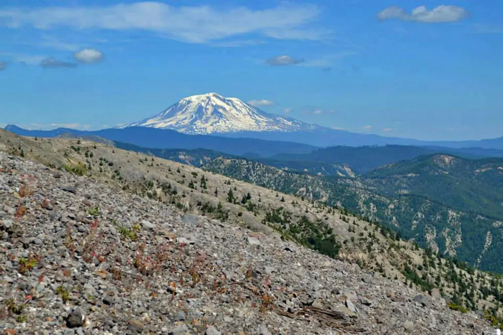
12. Mount Adams — Washington’s Overlooked Giant
At 12,281 feet, Mount Adams is the second-highest peak in Washington State, and one of the most undervisited given its scale. Unlike Rainier, there is no park entry fee and the infrastructure around Adams is minimal — which is exactly why people who know about it keep going back. The Yakama Nation manages part of the mountain, and some routes require a recreation permit. The wildflower meadows on the south side in late summer are comparable to anything at Rainier.
13. Palouse Falls State Park — Washington’s Official State Waterfall
Palouse Falls drops 198 feet into a basalt canyon in eastern Washington — about as far from the image of lush western Washington as you can get. The landscape here is open, arid, and carved by ancient floods. It was designated the official state waterfall in 2014. Day use requires a Washington State Discover Pass (approximately $10/day or $45/year).
14. Snoqualmie Falls — The Most Visited Natural Site in Washington
Snoqualmie Falls is 268 feet tall — 100 feet taller than Niagara Falls — and sits about 30 miles east of Seattle, making it the most accessible major waterfall in the state. The upper viewpoint is free and only a short walk from the parking area. A lower trail leads down closer to the base and takes around 20–30 minutes round-trip. The falls generate hydroelectric power, and there has been a power plant operating on site since 1899. Arrive early on weekends to avoid the tour bus crowds.
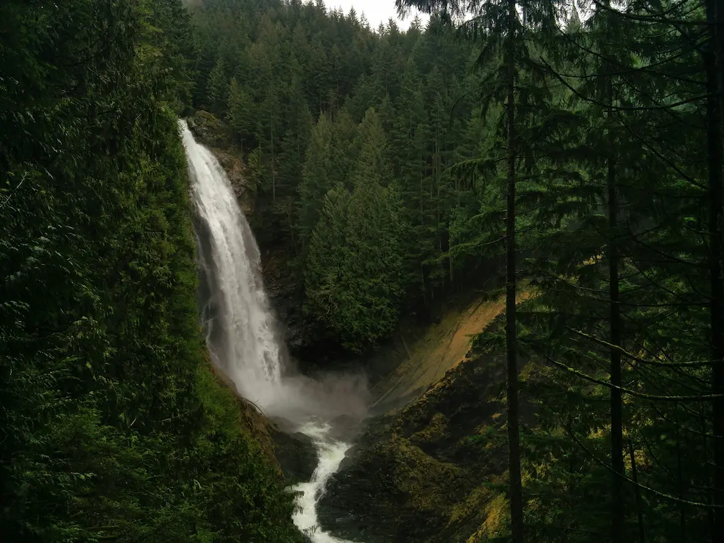
15. Franklin Falls — The Easiest Waterfall Hike in the Cascades
Franklin Falls requires almost no effort — the trail is about 1 mile round-trip, mostly flat, and free to access. It sits off I-90 near Snoqualmie Pass, which means it is genuinely on the way to or from many eastern Washington destinations. The falls drop about 70 feet into a rocky pool and stay accessible most of the year outside of heavy snow conditions. It is a good stop to break up a longer drive without committing to a full hike.
16. Moulton Falls Regional Park — A Local Favorite That Rarely Appears on Tourist Lists
Moulton Falls sits in Clark County in southwestern Washington and is almost entirely off the radar for visitors from outside the region. The park centers on a natural arched stone bridge over the Lewis River — one of the few natural arched bridges in the Pacific Northwest. The trails here are free and well-maintained. If you are traveling between Portland and Mount St. Helens, this is an easy and worthwhile detour.
17. Dry Falls — The Ghost of the World’s Largest Waterfall
During the Ice Age floods, Dry Falls carried more water than all the rivers on Earth combined. Today it is silent — a 3.5-mile-wide, 400-foot-tall cliff face in eastern Washington with no water running over it. The scale takes a moment to process even when you are standing at the viewpoint. The interpretive center at Sun Lakes-Dry Falls State Park explains the geology clearly. A Discover Pass is required for day use (approximately $10/day or $45/year).
18. Ruby Beach — Sea Stacks, Driftwood, and Tide Pools
Ruby Beach is one of the more dramatic beaches on the Olympic Peninsula, with basalt sea stacks rising from the surf and massive driftwood logs piled along the shore. It is included in Olympic National Park entry (approximately $30/vehicle), and access is a short walk from the parking area just off Highway 101. Tide pools are best explored at low tide. The combination of sea stacks, fog, and dark sand gives it a look that is unlike anything on the East Coast.
19. Rialto Beach — Walk to the Hole-in-the-Wall Arch
Rialto Beach sits further north on the Olympic Peninsula than Ruby Beach and draws fewer day visitors. The main draw is a 1.5-mile walk north along the beach to Hole-in-the-Wall, a rock arch carved by waves that you can walk through at low tide. Check tide timing before you go — access closes at high tide. Also included in Olympic NP entry. The walk along the beach is on loose rocks and driftwood, so sturdy footwear makes a difference.
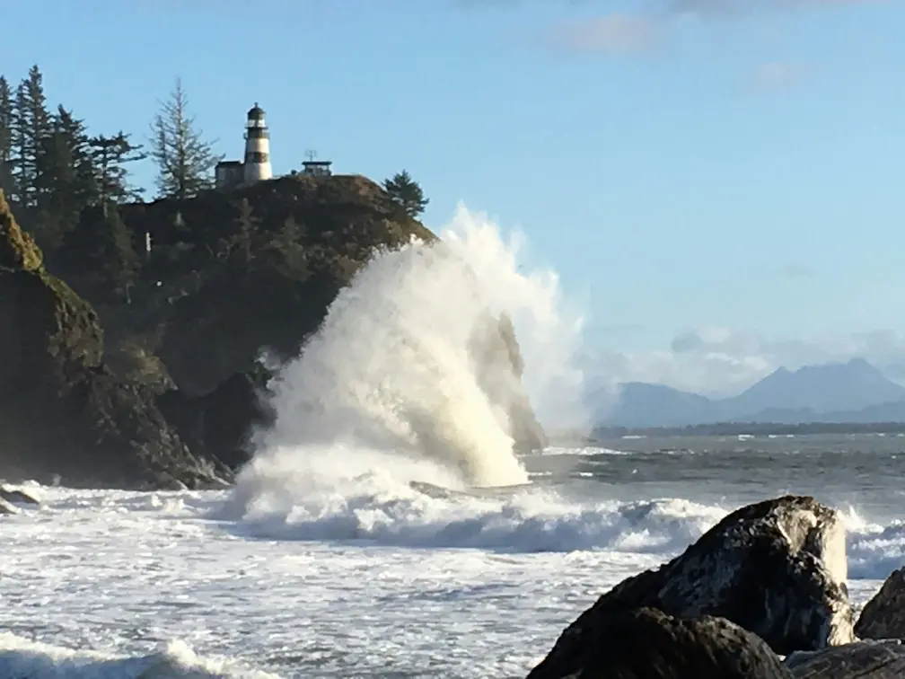
20. Cape Flattery — The Northwesternmost Point in the Contiguous US
Cape Flattery is as far northwest as you can go on the continental United States. A 0.75-mile trail through old-growth forest leads to clifftop boardwalks with views of the Pacific, sea caves, and the Cape Flattery Lighthouse on Tatoosh Island. This area is located on the Makah Reservation, and a Makah Recreation Pass is required (approximately $20/vehicle). The drive to Neah Bay alone is worth the trip.
21. Deception Pass State Park — Washington’s Most Visited State Park
Deception Pass consistently draws more visitors than any other state park in Washington. The signature feature is the bridge spanning two narrow, churning channels between Whidbey Island and Fidalgo Island — the tidal currents here move fast enough to be genuinely dramatic. Day use requires a Discover Pass (approximately $10/day or $45/year). The park also has miles of hiking trails, a campground, and saltwater access for kayaking.
22. San Juan Islands — Watch Orcas from Shore for Free
The San Juan Islands are accessible by Washington State Ferry from Anacortes, and ferry prices vary by season — vehicle reservations are essential in summer, while walk-on passengers have much more flexibility. On San Juan Island specifically, Lime Kiln Point State Park is one of the best land-based orca watching spots in the world. Southern Resident orcas pass through the area regularly between May and September, and the viewing platform at Lime Kiln is free. No boat required.
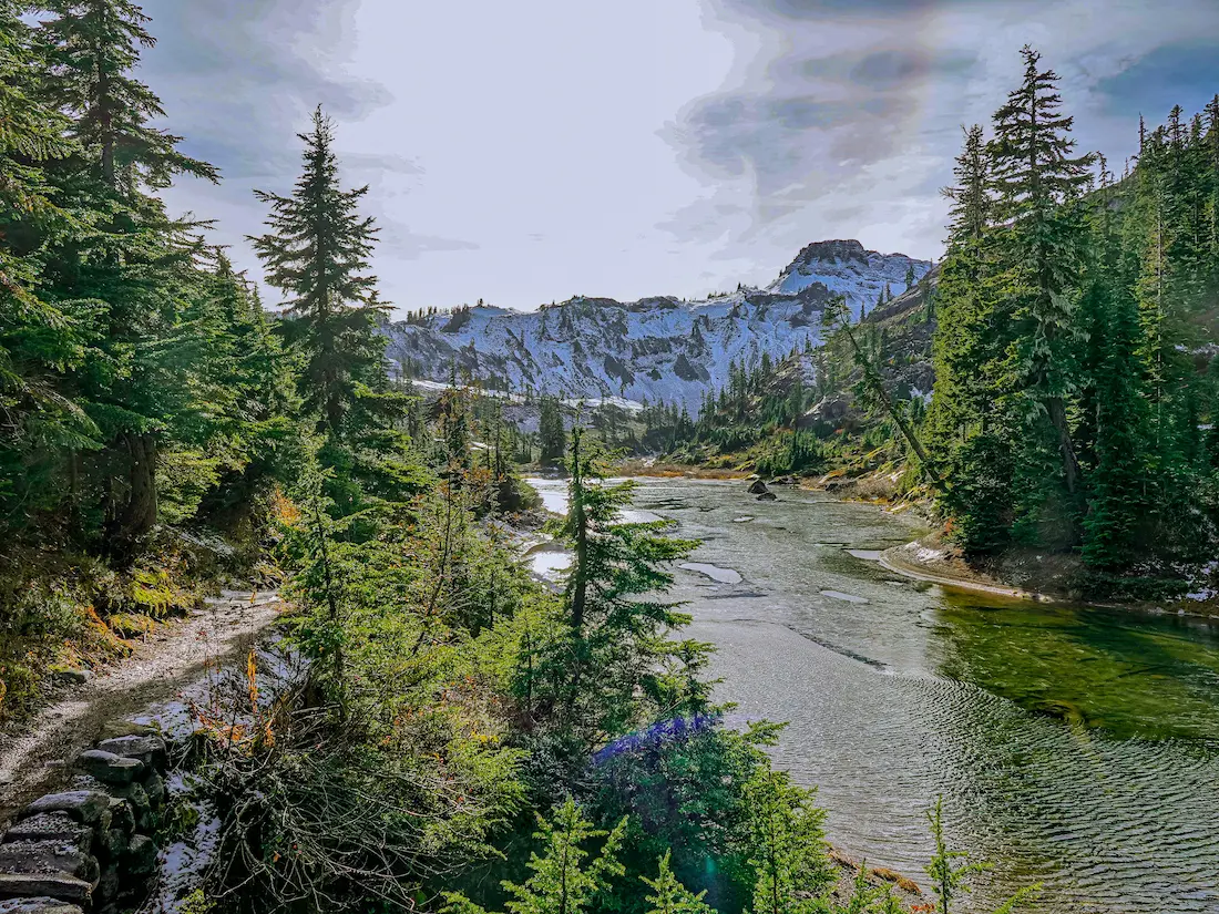
23. Lake Crescent — Unusually Clear Water Inside Olympic NP
Lake Crescent sits inside Olympic National Park and has water clarity that surprises most first-time visitors. The reason: the lake is naturally low in nitrogen, which limits algae growth and keeps the water a deep, almost unreal blue. The Storm King Mountain trail above the lake is a moderate 3.4-mile round-trip with significant elevation gain and views over the water. Rowboat rentals are available seasonally at the Lake Crescent Lodge if you prefer to stay at water level.
24. Quinault Rain Forest — Less Visited, Just as Impressive
The Quinault Rain Forest occupies the southwestern corner of Olympic National Park and receives less than a tenth of the visitors that the Hoh does. The world’s largest known Sitka spruce tree lives here — it is roughly 191 feet tall and over 1,000 years old. The loop trail through the old-growth forest is about 4 miles and mostly flat. The town of Quinault has basic services including a historic lodge if you want to base yourself in this part of the park.
25. Hoh Rain Forest — Hall of Mosses Trail
Already mentioned in the National Parks section, but worth a separate note for planning purposes: the Hall of Mosses is a 0.8-mile loop and one of the most recognized forest walks in the Pacific Northwest. The bigleaf maple trees here are draped in club moss that hangs from every branch. The trail is accessible year-round, though the moss looks best when it is wet — which, given 140 inches of annual rainfall, is most of the time.
26. Diablo Lake — Turquoise Water Visible from the Highway
Diablo Lake sits inside the North Cascades complex and is the most accessible example of glacial flour coloring in Washington. The turquoise color comes from fine particles of glacially-ground rock suspended in the water, which scatter light differently than clear water. The main viewpoint is reachable from Highway 20 without any hiking — just a short walk from a pull-off.
27. Lake Chelan — Third Deepest Lake in the United States
Lake Chelan is 55 miles long and reaches a depth of up to 1,486 feet, making it the third deepest lake in the US. The town of Chelan on the eastern end is the main base for visitors, with hotels, wineries, and direct access to the water. A passenger ferry runs the length of the lake to Stehekin, a remote village at the far end with no road access — the trip takes about four hours each way and day trips are possible if you time the return ferry correctly.
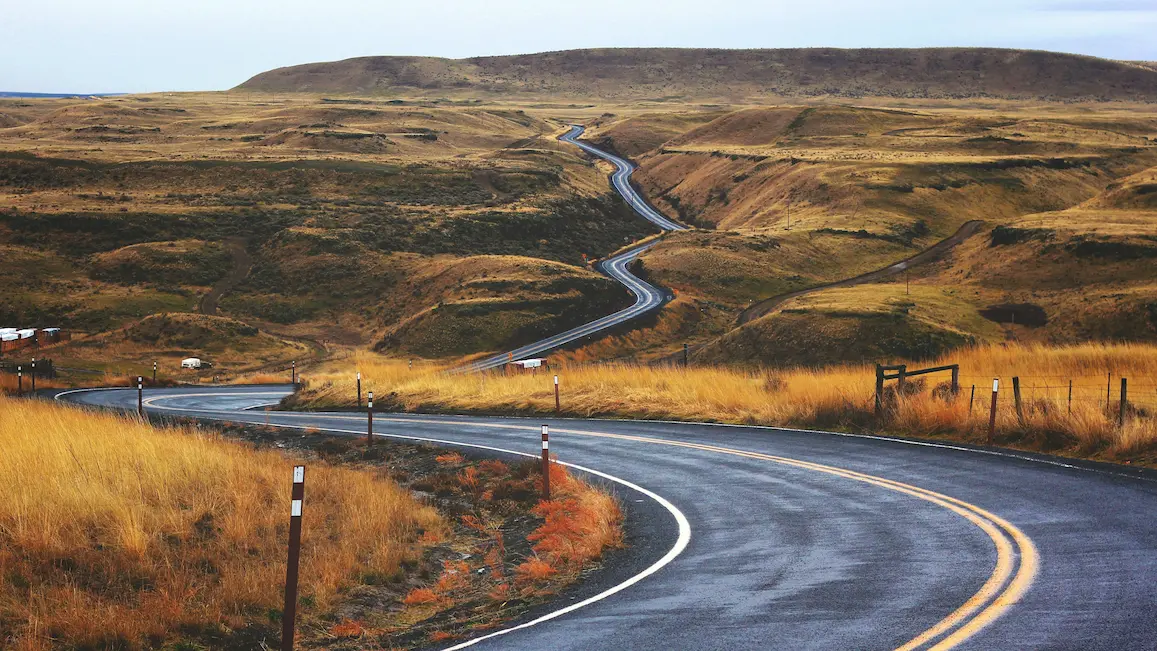
28. Palouse Hills — Rolling Agricultural Landscape at Its Peak in Late May
The Palouse Hills in southeastern Washington look nothing like the rest of the state. The rolling hills are formed from deep windblown soil deposits called loess, and in late May the wheat and lentil crops create a patchwork of greens, yellows, and browns that photographs well from elevated viewpoints. Steptoe Butte State Park gives you a 360-degree view from about 3,600 feet — it is free to access and the road to the top is paved.
29. Channeled Scablands — A Landscape Found Nowhere Else on Earth
The Channeled Scablands cover a large portion of eastern Washington and represent one of the most geologically unusual landscapes in North America. They were carved by catastrophic Ice Age floods that geologists estimate moved more water in a matter of days than the Amazon River carries in years. The terrain is a mix of basalt coulees, dry waterfalls, and channels etched into the plateau.
30. Ginkgo Petrified Forest State Park — 15 Million Years of History on the Columbia River
Ginkgo Petrified Forest sits near Vantage on the Columbia River and protects one of the most diverse petrified wood deposits in the world. The interpretive trail is free to access and displays petrified logs from trees that grew here 15 million years ago when the climate was subtropical. Petrified ginkgo wood is rare globally, and this is one of the few places where it has been found in significant quantities. The overlook above the Columbia River adds a secondary reason to stop even if geology is not your main interest.
The America the Beautiful Annual Pass ($80 for US residents) covers entry to Olympic National Park, Mount Rainier National Park, and the Mount St. Helens National Volcanic Monument. If you are visiting more than one of those three, the pass pays for itself on the first or second stop.
The Washington State Discover Pass (approximately $45/year or $10/day) covers most state parks, including Palouse Falls, Deception Pass, and Sun Lakes-Dry Falls. If you are doing a multi-day road trip with stops at state parks, the annual pass is the better option.
A few things that require advance planning: Cape Flattery requires a Makah Recreation Pass (approximately $20/vehicle), which is not covered by national park passes and must be purchased locally. The San Juan Islands ferry fills up fast in summer for vehicles — walk-on passengers have much more flexibility and can often get on same-day. North Cascades Highway 20 typically closes from around November through April, so Diablo Lake and the North Cascades are essentially a summer and fall destination.
Ape Cave at Mount St. Helens is not covered by the America the Beautiful Pass — it has its own separate fee. And eastern Washington is dramatically drier and sunnier than the western side of the Cascades, so pack and plan accordingly if you are crossing the mountains.
Washington State is one of the most varied natural landscapes in the United States, and most of it is accessible without an extreme budget or extreme fitness level. You can walk through a temperate rainforest in the morning, eat lunch beside a glacially-fed turquoise lake in the afternoon, and camp under the stars in high desert terrain the next night.
The America the Beautiful Pass and the Discover Pass together run about $125 and cover the majority of entry fees on this list. That is a solid starting point for a week-long Washington State road trip. Whether you are coming for the national parks, the volcanic terrain, the coast, or the quiet corner of eastern Washington that most visitors never reach — the state has something specific for every kind of traveler.